Case studies
The following case studies offer a sample of innovative solutions for a wide range of clients by Spatial Intelligence

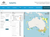
NIMPIS - Department of Agriculture
The National Introduced Marine Pest Information System (NIMPIS) is a central repository of marine pest information to assist Australian decision makers in the event of an incursion/outbreak. NIMPIS contains detailed information on the biology, ecology and distribution of marine pest species known to have been introduced to Australia, or considered to be a risk of future introduction. read more...
Property Management System - Mine Subsidence Board
The purpose of the Property Management System is to record, manage and report on information about properties within the areas subject to the Mine Subsidence Compensation Act and any transactions relating to those properties administered by the Mine Subsidence Board. read more...
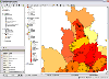
Development Assessment Register - Sydney Catchment Authority
The SCA required a system to manage the assessment of development applications within the Sydney water catchment and automate numerous development assessment and catchment information functions. Spatial Intelligence was commissioned to develop a spatially enabled application to meet these requirements. read more...
DocuMap - Wagga Wagga City Council
Wagga Wagga City Council required an electronic plan management system. They were seeking a system that was geographically based that would link to their GIS system. DocuMap was chosen and implemented to meet the requirements. read more...
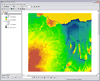
Frost modelling - University of Western Sydney
The University of Western Sydney required a method that could spatially interpret the relationship of plant yields, frost and topography. read more...
Development Assessment Module - Sydney Catchment Authority
The SCA required a system to assess the potential risk of individual on-site effluent management systems. Spatial Intelligence was commissioned to develop a spatially enabled application to meet these requirements. read more...
Compliance Support System - Sydney Catchment Authority
The SCA required an integrated information system to support staff and management in the performance of the SCA's compliance program. Spatial Intelligence was commissioned to develop a spatially enabled application to meet these requirements. read more...
DocuMap - Mine Subsidence Board
The MSB realised that it needed to replace its existing Information Management System (IMS) with a more modern, reliable and efficient system. Spatial Intelligence is part of a consortium that won a tender to supply and implement the new IMS. read more...