University of Western Sydney:
Frost modeling
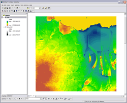
ArcGIS extension with colour ramp
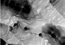
Resulting model with greyscale ramp
project name
University of Western Sydney - Frost modeling
the aim
As part of Dr Frank Kelleher's, of University of Western Sydney (UWS), research into the relationship of plant yields, frost and topography, Dr Daniel Martens (of Martens and Associates) developed a relationship between frost, temperature and topography. A method was required whereby various data sets could be entered into that model to produce an automated spatially interpretive result. This could then be used to verify the model.
the solution
Spatial Intelligence was commissioned to produce a Frost modeling ArcGIS extension that could:- Input the model parameters
- Extract the relevant information from the GIS for a large number of sample points.
- Interpolate and process the data in accordance with the model
- Produce a raster output suitable for further analysis
The model can be run for any number of sites and re-run with different parameters as required.
- Microsoft Windows
- ESRI ArcGIS
Tags
more details
For more details please use our 'Contact us' page or email us at info@spatialintelligence.com.au